stdClass Object
(
[type] => Land
[status] => stdClass Object
(
[current] => Active Under Contract
[last] => Active
[changed] => 2025-08-30T12:29:00
)
[ml_number] => 2823997
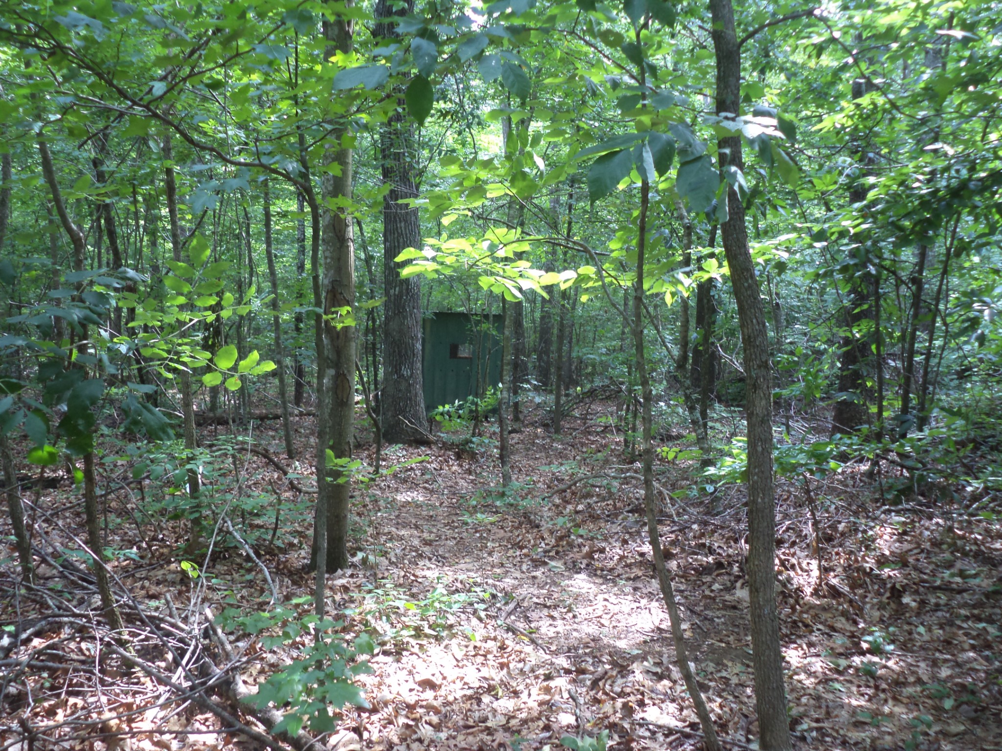
[price] => stdClass Object
(
[amount] => 339900
[original] => 389900
[last_changed_on] => 2025-07-01T10:21:00
)
[listing_flags] => Array
(
[0] => Financing
)
[available_on] => stdClass Object
(
[$date] => 2025-04-28T04:00:00Z
)
[description] => Cannon County, 42.14 acres with so many possibilities! See attached soil test for septic system. There are many sites on the property that are high and soil is great seller said. City water, electric, fiber optics in place and natural gas out front! See attached a drawing of how the land can be divided into 4 lots. Owners are in the process of getting property perked. Driveway entrance on left side of property installed and flags show where path on the property begins. Come Build your dream home, property is level and could have development possibilities. There is an old small pond on property (maybe 2), trail roads cut all around the outside of the property and through the middle, the property has been under brush cut. The property is perfect for hunting, raising livestock and building your dream home. This is 42.14 acres of the attached tax card. Owners will not sale the 5.27 acres. This property was separate and put together. Property was surveyed a couple years ago and ribbons are up on post. This property is close to Bradyville, Woodbury, Manchester, Bell Buckle Murfreesboro, I-24 and McMinnville.
[location] => stdClass Object
(
[city] => Bradyville
[state] => Tennessee
[postal_code] => 37026
[county] => Cannon County, TN
[street] => stdClass Object
(
[number] => 0
[name] => Preacher Spry Road
[full] => 0 Preacher Spry Road
)
[directions] => 24 W, exit 97 turn left onto Beechgrove Rd, right onto Murfreesboro Hwy, go 1.5 miles left onto McBrides Branch Rd, turn left onto Paul Harrell Rd, turn right onto K Parker Rd, turn left onto Espy Rd, turn right onto Preacher Spry Rd, property on the left
[coordinates] => stdClass Object
(
[latitude] => 35.677165
[longitude] => -86.103243
[geo_json] => stdClass Object
(
[type] => Point
[coordinates] => Array
(
[0] => -86.103243
[1] => 35.677165
)
)
)
)
[building] => stdClass Object
(
[square_feet] => stdClass Object
(
[size] => 0
)
[fireplaces] => stdClass Object
(
[exists] =>
)
)
[surroundings] => stdClass Object
(
[land] => stdClass Object
(
[size] => stdClass Object
(
[acres] => 42.14
)
[description] => Array
(
[0] => Level
)
)
[school] => stdClass Object
(
[elementary] => Cannon County Elementary School
[junior] => Cannon County Middle School
[high] => Cannon County High School
)
)
[last_updated] => stdClass Object
(
[$date] => 2025-08-30T16:29:00Z
)
[office] => stdClass Object
(
[name] => eXp Realty
[broker_id] => 3635
)
[agents] => Array
(
[0] => stdClass Object
(
[name] => stdClass Object
(
[first] => Sheila
[last] => Campbell
)
[phone] => stdClass Object
(
[preferred] => 9312738504
[mobile] => 9312738504
[fax] => 6153330713
)
[agent_id] => 4968
)
)
[media] => stdClass Object
(
[photos] => Array
(
[0] => stdClass Object
(
[position] => 0
[description] => Deer on the property. This property has bee under cut to allow for more openness. This property has city water, electric, natural gas and Fiber Optics at the road. A convert was put in with gravel for a great driveway on the left side.
[urls] => stdClass Object
(
[original] => https://new.photos.idx.io/rt2/2823997/0.jpg
[215x] => https://new.photos.idx.io/rt2/2823997/0/215x.jpg
[440x] => https://new.photos.idx.io/rt2/2823997/0/440x.jpg
)
)
[1] => stdClass Object
(
[position] => 1
[description] => The trails go around the outside of the property and through it. There are deer stands on the property as well. Water, electric, fiber optics and natural gas in front at road. There is already a covert in place with gravel in place.
[urls] => stdClass Object
(
[original] => https://new.photos.idx.io/rt2/2823997/1.jpg
[215x] => https://new.photos.idx.io/rt2/2823997/1/215x.jpg
[440x] => https://new.photos.idx.io/rt2/2823997/1/440x.jpg
)
)
[2] => stdClass Object
(
[position] => 2
[description] => More of the trails. The property was under cut a few years ago and easy to get through . Allows from deer hunting and will be easier to clear a spot out for a house. There is some old farm fencing around most of the property
[urls] => stdClass Object
(
[original] => https://new.photos.idx.io/rt2/2823997/2.jpg
[215x] => https://new.photos.idx.io/rt2/2823997/2/215x.jpg
[440x] => https://new.photos.idx.io/rt2/2823997/2/440x.jpg
)
)
[3] => stdClass Object
(
[position] => 3
[description] => The front of the property out by the road. If facing the property there is a driveway with new convert and gravel on the left hand side. There are flags showing you were the trails begin there.
[urls] => stdClass Object
(
[original] => https://new.photos.idx.io/rt2/2823997/3.jpg
[215x] => https://new.photos.idx.io/rt2/2823997/3/215x.jpg
[440x] => https://new.photos.idx.io/rt2/2823997/3/440x.jpg
)
)
[4] => stdClass Object
(
[position] => 4
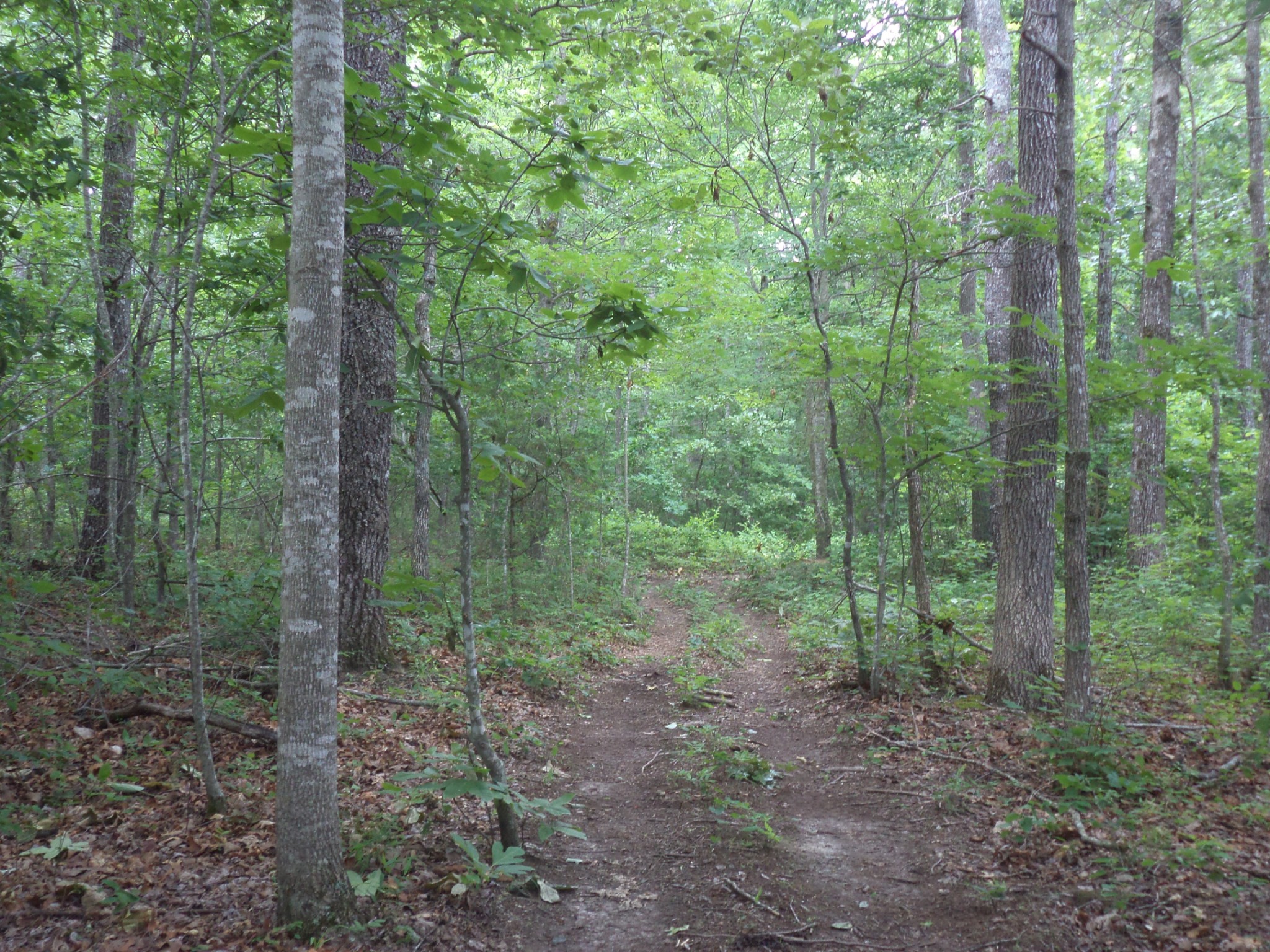
[description] => There are trails cut through out the property. There is one trail along the outside of the entire 42.14 acres. This property is close to I-24, Woodbury, Bradyville, Manchester, Murfreesboro and McMinnville.
[urls] => stdClass Object
(
[original] => https://new.photos.idx.io/rt2/2823997/4.jpg
[215x] => https://new.photos.idx.io/rt2/2823997/4/215x.jpg
[440x] => https://new.photos.idx.io/rt2/2823997/4/440x.jpg
)
)
[5] => stdClass Object
(
[position] => 5
[description] => More trailers. See how open it is and owner is working on getting a perk spot.
[urls] => stdClass Object
(
[original] => https://new.photos.idx.io/rt2/2823997/5.jpg
[215x] => https://new.photos.idx.io/rt2/2823997/5/215x.jpg
[440x] => https://new.photos.idx.io/rt2/2823997/5/440x.jpg
)
)
[6] => stdClass Object
(
[position] => 6
[description] => This is an area where a small old pond once was. It needs to be cleaned out
[urls] => stdClass Object
(
[original] => https://new.photos.idx.io/rt2/2823997/6.jpg
[215x] => https://new.photos.idx.io/rt2/2823997/6/215x.jpg
[440x] => https://new.photos.idx.io/rt2/2823997/6/440x.jpg
)
)
[7] => stdClass Object
(
[position] => 7
[description] => Front of the property. The land was under cut several years ago. It is wooded but easy to get through. All services at the road:water, electric, fiber optics and natural gas
[urls] => stdClass Object
(
[original] => https://new.photos.idx.io/rt2/2823997/7.jpg
[215x] => https://new.photos.idx.io/rt2/2823997/7/215x.jpg
[440x] => https://new.photos.idx.io/rt2/2823997/7/440x.jpg
)
)
[8] => stdClass Object
(
[position] => 8
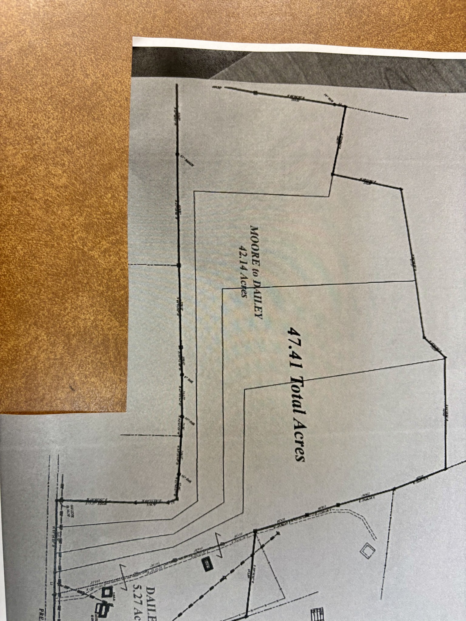
[description] => This is a survey of all the land. The dotted line goes right along the line of the 42.14 acres showing the division from the 5.27 acres owner is keeping
[urls] => stdClass Object
(
[original] => https://new.photos.idx.io/rt2/2823997/8.jpg
[215x] => https://new.photos.idx.io/rt2/2823997/8/215x.jpg
[440x] => https://new.photos.idx.io/rt2/2823997/8/440x.jpg
)
)
[9] => stdClass Object
(
[position] => 9
[description] => The dotted line is where the division will be. This was 2 separate pieces and he combined. We have legal description for each piece
[urls] => stdClass Object
(
[original] => https://new.photos.idx.io/rt2/2823997/9.jpg
[215x] => https://new.photos.idx.io/rt2/2823997/9/215x.jpg
[440x] => https://new.photos.idx.io/rt2/2823997/9/440x.jpg
)
)
[10] => stdClass Object
(
[position] => 10
[description] => There are deer stands on the property. Seller may take one with him.
[urls] => stdClass Object
(
[original] => https://new.photos.idx.io/rt2/2823997/10.jpg
[215x] => https://new.photos.idx.io/rt2/2823997/10/215x.jpg
[440x] => https://new.photos.idx.io/rt2/2823997/10/440x.jpg
)
)
[11] => stdClass Object
(
[position] => 11
[description] => The paths are great. You can hunt, ride your 4 wheelers
[urls] => stdClass Object
(
[original] => https://new.photos.idx.io/rt2/2823997/11.jpg
[215x] => https://new.photos.idx.io/rt2/2823997/11/215x.jpg
[440x] => https://new.photos.idx.io/rt2/2823997/11/440x.jpg
)
)
[12] => stdClass Object
(
[position] => 12
[description] => This shows how open it is even though wooded
[urls] => stdClass Object
(
[original] => https://new.photos.idx.io/rt2/2823997/12.jpg
[215x] => https://new.photos.idx.io/rt2/2823997/12/215x.jpg
[440x] => https://new.photos.idx.io/rt2/2823997/12/440x.jpg
)
)
[13] => stdClass Object
(
[position] => 13
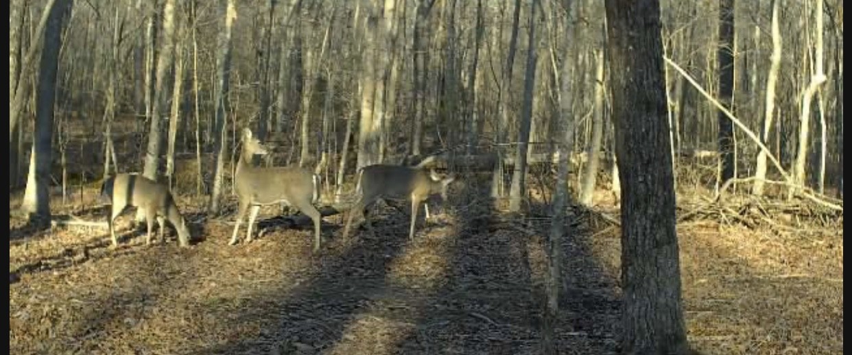
[description] => The land has deer and wild turkey
[urls] => stdClass Object
(
[original] => https://new.photos.idx.io/rt2/2823997/13.jpg
[215x] => https://new.photos.idx.io/rt2/2823997/13/215x.jpg
[440x] => https://new.photos.idx.io/rt2/2823997/13/440x.jpg
)
)
[14] => stdClass Object
(
[position] => 14
[urls] => stdClass Object
(
[original] => https://new.photos.idx.io/rt2/2823997/14.jpg
[215x] => https://new.photos.idx.io/rt2/2823997/14/215x.jpg
[440x] => https://new.photos.idx.io/rt2/2823997/14/440x.jpg
)
)
[15] => stdClass Object
(
[position] => 15
[urls] => stdClass Object
(
[original] => https://new.photos.idx.io/rt2/2823997/15.jpg
[215x] => https://new.photos.idx.io/rt2/2823997/15/215x.jpg
[440x] => https://new.photos.idx.io/rt2/2823997/15/440x.jpg
)
)
[16] => stdClass Object
(
[position] => 16
[urls] => stdClass Object
(
[original] => https://new.photos.idx.io/rt2/2823997/16.jpg
[215x] => https://new.photos.idx.io/rt2/2823997/16/215x.jpg
[440x] => https://new.photos.idx.io/rt2/2823997/16/440x.jpg
)
)
[17] => stdClass Object
(
[position] => 17
[description] => Legal description of the land
[urls] => stdClass Object
(
[original] => https://new.photos.idx.io/rt2/2823997/17.jpg
[215x] => https://new.photos.idx.io/rt2/2823997/17/215x.jpg
[440x] => https://new.photos.idx.io/rt2/2823997/17/440x.jpg
)
)
[18] => stdClass Object
(
[position] => 18
[description] => Possible division of the land if buyer wanted to divide
[urls] => stdClass Object
(
[original] => https://new.photos.idx.io/rt2/2823997/18.jpg
[215x] => https://new.photos.idx.io/rt2/2823997/18/215x.jpg
[440x] => https://new.photos.idx.io/rt2/2823997/18/440x.jpg
)
)
[19] => stdClass Object
(
[position] => 19
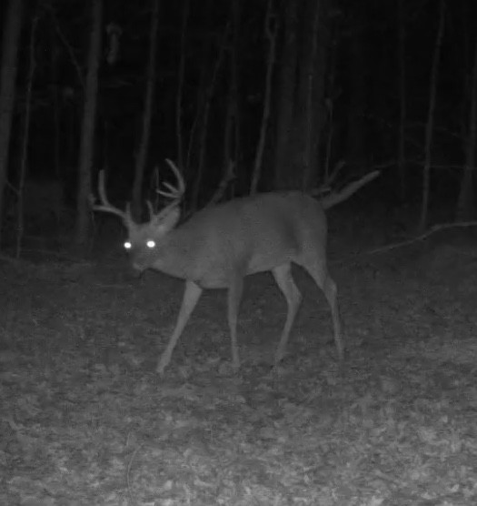
[description] => Deer picture taken with deer cameras
[urls] => stdClass Object
(
[original] => https://new.photos.idx.io/rt2/2823997/19.jpg
[215x] => https://new.photos.idx.io/rt2/2823997/19/215x.jpg
[440x] => https://new.photos.idx.io/rt2/2823997/19/440x.jpg
)
)
[20] => stdClass Object
(
[position] => 20
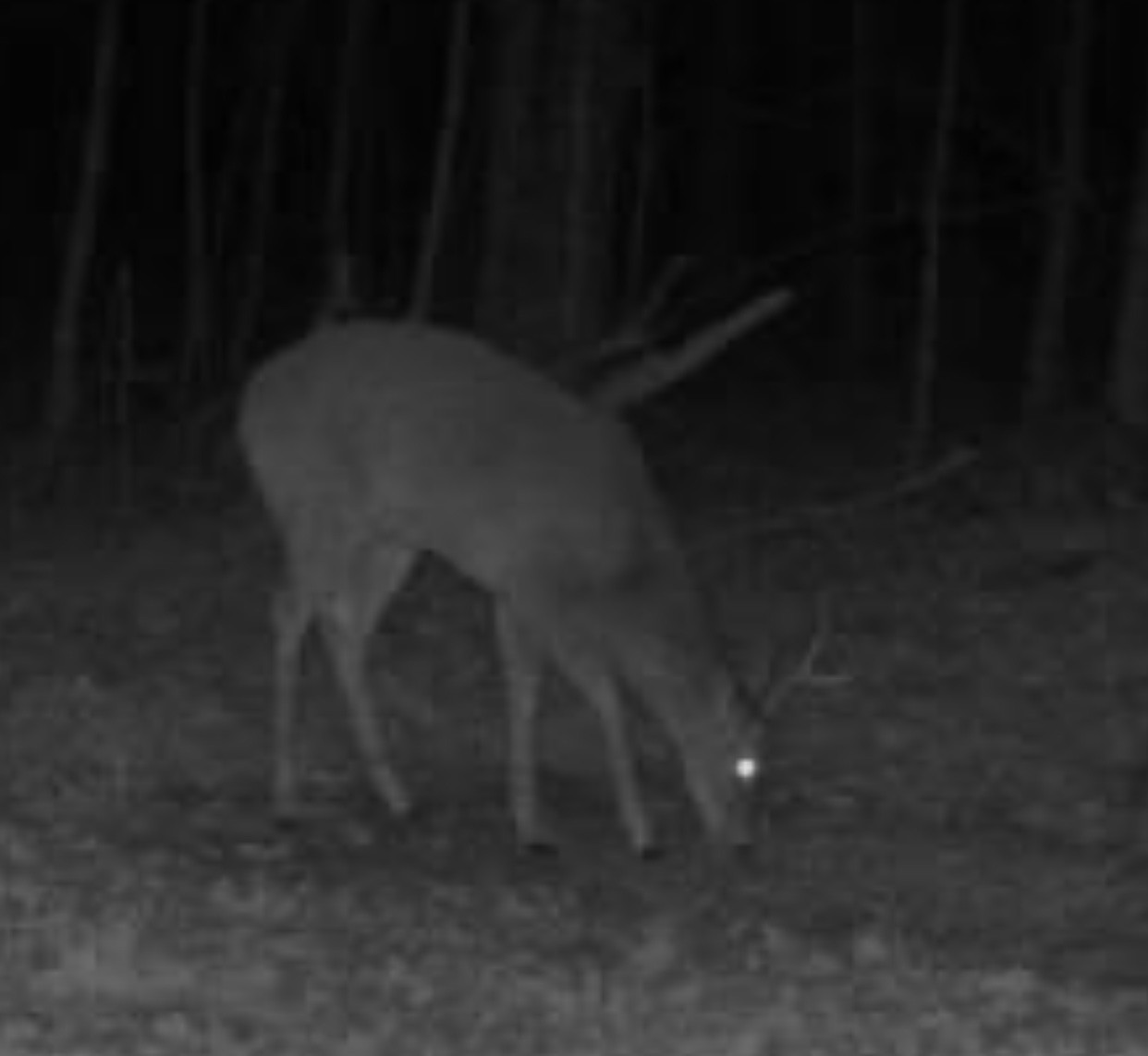
[description] => Deer from night cameras
[urls] => stdClass Object
(
[original] => https://new.photos.idx.io/rt2/2823997/20.jpg
[215x] => https://new.photos.idx.io/rt2/2823997/20/215x.jpg
[440x] => https://new.photos.idx.io/rt2/2823997/20/440x.jpg
)
)
[21] => stdClass Object
(
[position] => 21
[urls] => stdClass Object
(
[original] => https://new.photos.idx.io/rt2/2823997/21.jpg
[215x] => https://new.photos.idx.io/rt2/2823997/21/215x.jpg
[440x] => https://new.photos.idx.io/rt2/2823997/21/440x.jpg
)
)
[22] => stdClass Object
(
[position] => 22
[urls] => stdClass Object
(
[original] => https://new.photos.idx.io/rt2/2823997/22.jpg
[215x] => https://new.photos.idx.io/rt2/2823997/22/215x.jpg
[440x] => https://new.photos.idx.io/rt2/2823997/22/440x.jpg
)
)
[23] => stdClass Object
(
[position] => 23
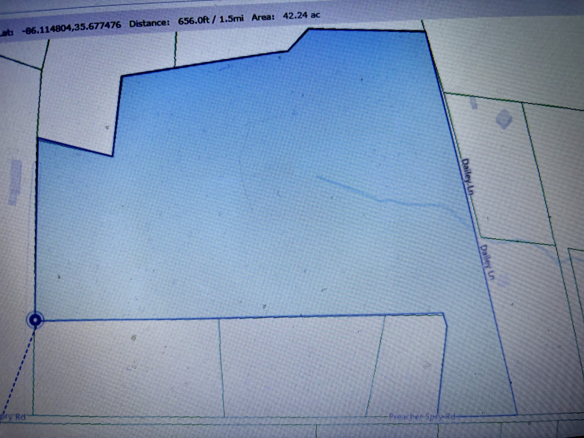
[description] => This is an estimate coloring of parcel being sold.
[urls] => stdClass Object
(
[original] => https://new.photos.idx.io/rt2/2823997/23.jpg
[215x] => https://new.photos.idx.io/rt2/2823997/23/215x.jpg
[440x] => https://new.photos.idx.io/rt2/2823997/23/440x.jpg
)
)
)
)
[key] => rt-2823997
[added_at] => stdClass Object
(
[$date] => 2025-04-29T04:05:01Z
)
[source] => rt
[self_link] => https://api.idx.io/listings/rt-2823997
)
Exterior Details
- Lot DescriptionLevel
- Acres42.14